
- I find riding east (Pittsburgh to DC) far preferable due to the slope.
- the Pittsburgh-Cumberland section is so superior to the southern half that if your goal is to ride 300 miles and have fun — ride the northern half round-trip.
My group was in and around Williamsport MD and there was a tremendous storm - rain, wind, lightning. I saw a shed get blown off its concrete pad and up into the trees, and down the street a barn was blown off its foundation. There was major damage on the trail, a lot of trees down across the path - some major blockages - and quite a bit of flooding and mud.

The next morning we gathered in a Waffle House (they're doing some great things with hash browns these days) and tried to figure out if the trail was navigable. In the two miles that we'd surveyed between MP102 and MP100 there were four trees down across the trail.
Inevitably, we decided to eat breakfast (always a good move) as we waiting for the National Park Service to open their office and see what info they had on trail conditions.
About 0930 we troop in to the NPS (they operate the trail) and ask the Ranger on duty, what's the trail condition after the storm? He says, No problem, nothing wrong but here's our phone number, if you should see a downed tree please give us a call.
A rider in our group said, "there's four down trees between MP102 and MP100" and the Ranger wrote that down and said, "Thanks, we didn't know about that". And we left, realizing that they had no information at all about trail conditions. How could they? And so we went out to see what adventure the day held, and encountered things like this:

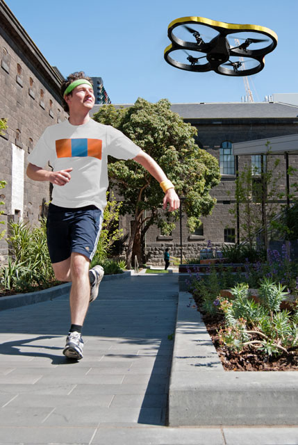
One of the cyclists was a fellow
I suggested that with current trends, the NPS will inevitably have drones that they could send out along the trail, or maybe send out to follow a group of riders and report back on conditions. Wouldn't cost much, the info relay would be timely, etc.
Be careful what you prognosticate about, or maybe you should just patent every notion. Just a week later, in today's news is the story of the JoggoBot, your new drone exercise buddy! It uses the colored grid on the T-shirt to orient itself to the
In its current positioning, the JoggoBot is a personal device; it's all about You — and that's pretty smart if they're marketing to individuals. Imagine when they get enough early adopters on board and take the marginally free next step of networking them into a swarm; we'll move from a personal TrailBuddy™ to a TrailBuddyNet™. Total information awareness, n'at.
 In a way, the TrailBuddies will need branding to ensure they're perceived correctly. I think they should be called "Lassie" - Lassie549, Lassie789 etc. You know, Little Timmy is stuck in the old well and Lassie goes home and barks and the Mom says, "what's that Lassie? Timmy's stuck in the old well? Gosh!" Same schtick.
The Park Service could ask every nth group, "hey would you take our Trail Monitor Drone along with you on the trail? You'll get free pictures you can download."
What could go wrong?


0 comments:
Post a Comment
Comments and Feedback? Love that stuff. Please leave your thoughts in the box below--